Sunday, October 23, 2011

Adirondack Fall

Having travelled up to Vermont to see the fall foliage, it was now the turn of New York State. The plan was to head north up the I87 Northway and then pick up Route 28 just north of Lake George and follow it and the Hudson River across through North Creek to Indian Lake and then turn south on Route 30 to return following the Sacandaga River to Sacandaga Lake then Amsterdam and back to home. The route is designated as one of New York’s scenic byways. The weather started out very overcast with a few drops of rain now and then but later it cleared and the fall colours showed their beauty. Heading back the light started to go and gave a nice shot of the Sacandaga River thought the trees. 

Banks of the Hudson River


Unknown Lake on Route 28

Sun going down on the Sacandaga River
North Creek is a small town north of Lake George and it's claim to fame is that it is the home of the Saratoga & North Creek Railway. North Creek Railroad Station is a historic railroad station built in 1874. It was built as the northern terminus of the Adirondack Railway. It is the place where Theodore Roosevelt learned of the assassination of President William McKinley and of his accession to the Presidency of the United States. During World War II, magnetite, ilmenite, and titanium were shipped by rail from Tahawus by the Delaware and Hudson Railway who acquired the Adirondack Line from William West Durant in 1889. It ran through this region until September 1989 when the mine at Tahawus closed. The rocks in the area are also known for their garnets.


In 1998, the line was purchased by Warren County with plans to operate an excursion train to improve tourism and economic development in the area. In 1999, the Upper Hudson River Railroad began operating excursion trains south from North Creek to Riverside Station in Riparius. The Upper Hudson River Railroad lost their contract with Warren County on December 31, 2010, ending 11 years of operation. On April 8, 2011, it was announced that Iowa Pacific Holdings would take over operation of the route effective July 1, 2011. As part of the agreement, the Iowa Pacific agreed to operate a minimum of 182 tourist-oriented passenger trains over the line. Iowa Pacific began operating trains on July 14, 2011 as the Saratoga and North Creek Railroad. Unlike the Upper Hudson River Railroad, which ran the short distance to Riparius, the Saratoga and North Creek now operates over the entire 57-mile between Saratoga Springs and North Creek. North of North Creek the line is still abandoned and over grown as it runs along route 28 and the Hudson River.


North Creek Station


Saratoga & North Creek Railroad
http://www.sncrr.com

Friday, October 14, 2011

Fairies, photos and folk music

Sitting here touching up some wedding photos from the other weekend, made me thing how easy it is to alter things in this day and age. When I first started in photography techniques like burning and dodging as well as sandwiching negatives were common and to some, altering a photo and then re-taking it. All these required skill in the darkroom or a good eye as an artist. They say the camera cannot lie (although with some modern cameras that is not true today) but Photoshop can. Even so, I thought about one of the best camera tricks known, the Cottingley Fairies.
The Cottingley Fairies

In 1917, two Yorkshire girls, Elsie Wright and Frances Griffiths even managed to fool Sir Arthur Conan Doyle creator of super sleuth Sherlock Holmes, into believing they had photographed fairies at the bottom of their garden. Frances explained, "The first time I ever saw anything was when a willow leaf started shaking violently, even though there was no wind, I saw a small man standing on a branch, with the stem of the leaf in his hand, which he seemed to be shaking at something. He was dressed all in green..... They were real fairies. Some had wings and some not…. They were once sitting in a patch of sunlight on a low bank…. It all seemed so peaceful and friendly…. Sometimes they came up, only inches away, but I never wanted to join in their lives." The hoax wasn’t explained until 1982, when the pair finally admitted to photographing paper cut-outs supported by hat-pins. The Cottingley Fairies photographs fetched £6,000 at auction earlier this year, surely an indication that people still wish to believe in them. These days with Photoshop and similar software the creation of these abstract possibly believable images is easy if not something for experienced users.

Photoshop fairy


Even J R R Tolkien, author of Lord of the Rings, had a love affair with fairies and in his paper “On Fairy Stories” he wrote:

Supernatural is a dangerous and difficult word in any of its senses, looser or stricter. But to fairies it can hardly be applied, unless super is taken merely as a superlative prefix. For it is man who is, in contrast to fairies, supernatural (and often of diminutive stature); whereas they are natural, far more natural than he. Such is their doom. The road to fairyland is not the road to Heaven; nor even to Hell, I believe, though some have held that it may lead thither indirectly by the Devil's tithe.

O see ye not yon narrow road
So thick beset wi' thorns and briers?
That is the path of Righteousness,
Though after it but few inquires.

And see ye not yon braid, braid road
That lies across the lily leven?
That is the path of Wickedness,
Though some call it the Road to Heaven.

And see ye not yon bonny road
That winds about yon fernie brae?
That is the road to fair Elfland,
Where thou and I this night maun gae.

I recognized these as the words used by the English folk rock group Steeleye Span in their song Thomas the Rhymer recorded in 1974, so looking a little deeper I found that it was Child Ballad 37 - The Child Ballads are a collection of 305 ballads from England and Scotland collected by Francis James Child in the late nineteenth century. The collection was published as The English and Scottish Popular Ballads between 1882 and 1898 by Houghton Mifflin in 10 volumes.

Thomas himself was born Thomas Learmonth (c. 1220 – c. 1298) better known as Thomas the Rhymer or True Thomas and was a 13th century Scottish laird and reputed prophet from Earlston (then called "Erceldoune"). He is the protagonist of the ballad. He is also the probable source of the legend of Tam Lin. Popular esteem of Thomas lived on for centuries after his death, to the extent that several people have fabricated Thomas' "prophecies" in order to further the cause of Scottish independence. His reputation for supernatural powers for a time rivalled that of Merlin.

Thomas meets the Queen of the Fairies
All this might have been if  Sir Thomas of Erceldoune had been no more historical than Merlin. But the name is known to have belonged to a real person. Thomas Rymor de Ercildune is witness to a deed whereby one Petrus de Haga obliges himself to make payment to the Abbey of Melrose. Petrus de Haga is, in turn, witness to a charter made by Richard de Moreville. Unluckily, neither of these deeds is dated. But Moreville was constable of Scotland from 1162 to 1189. If we suppose Moreville's charter to have been given towards 1189, and Haga to have been then about twenty years old, and so born about 1170, and further suppose Haga to have made his grant to Melrose towards the end of a life of threescore, or three score and ten, the time of Thomas Rymer's signature would be about 1230 or 1240. If Thomas Rymer was then twenty years of age, his birth would have been at 1210 or 1220.

It never ceases to amaze me how one can jump from Photoshop and wedding photographs to folk music and the mystical worlds of fairies and elves, as some say everything is intertwined and the circle becomes complete.

J R R Tolkien – On Fairy Stories

Credit for the Photoshop Image

Credit for Thomas picture

Wednesday, October 12, 2011

Vermont Road Trip

This weekend was the Columbus Day holiday here in the States so time to get out and about especially with the trees turning into their fall colours. The Vermont State website suggested some routes which were in areas of peak or near peak colour so I planned to go up the Interstate to Rutland, Vermont about 100 miles north east of Albany and then cut across the Green Mountains doing a loop on the east side coming back down to Bennington and from there home. We got to Rutland and made a detour to visit the Mountain Top Tavern and Resort, just north of the town. The resoprt is on the shores of Chittenden Reservoir. Today it was busy with plenty of people out in canoes or just lazing around the beach area. The day was beautiful, the sky was blue and the temperature soared up to 85F (almost 30C). At the beach, I was amazed to see some women sunbathing in bikinis in the middle of October ! After lunch by the lake we headed east on the Vermont route 73 only to find it closed, the damage caused by hurricane Irene had still not been repaired.

Chittenden Reservoir

Vermont is an odd state; it is a state of two halves east and west with the Green Mountains running up the middle. There are only a few roads that run east – west and with this one being closed the only options were to drive 70 miles north or go down to Bennington and come back up, both these options would mean an additional 150 or so miles and several hours of travel so I decided to head north on the 53, following the shore of Lake Dunmore to pick up Route 7 and then head back down to Bennington.

Along Vermont Route 7
At Manchester we took the more scenic Historic Route 7, the predecessor of the modern highway Route 7. As I approached Bennington, I decided to take a back road back to New York and follow the Battenkill River to Hoosick and then pick up NY Route 7 back to Albany. The route numbers here confuse many, Vermont Rt7 continues in to Massachusetts changing to Mass Rt7 eventually ending up at Lee, while the NY Rt7 heads off the Vermont Rt7 at Bennington and back to Albany. It’s common to see cars pulled over with drivers pouring over maps trying to decide which route 7 they actually need.

The Battenkill River

The trees were good but not quite yet at peak in the southern half of Vermont, the turning comes south over the next couple of weeks so still a chance to get up in to the Adirondacks and Catskill Mountains to capture the brilliance of the Maples as they change to their fall coat of reds and oranges.

Saturday, September 24, 2011

Found Abandoned

One of the advantages of being a studio photographer is that you get a range of jobs. This may or not be good in terms of working, for example, This time of year is school photo time and this week I was given several of these school jobs. The down side is that you may be required to travel and have to carry a portable studio along with you; the upside is it helps the expense sheet…. This past week I have been working down state, south of Kingston, New York State, in the Catskill Mountains some 100 miles from home so with a 5am start and getting home at 6pm, it has not left me much time to sit down and write for my blog. Mother nature wasn't kind to me making sure sunrise came after I arrived at the school and ensuring rain was falling on my return journeys, making photographing the mountains almost impossible.


On Friday I was traveling home on a back road when I noticed some abandoned rail cars at the side of the road. With my love of things abandoned, I pulled over in a convenient space at the roadside and took some photos. With the pouring rain and me huddled under a very large umbrella camera round my neck, some passing motorists looked at me as though I had just escaped from the local asylum. A marker tells the public that this was once part of the O&W Railroad.


The Ontario and Western Railway, was a regional railroad with origins in 1868, the last passenger train departed Kingston for Oneonta in 1954, the company then lasted until 1957 when it was ordered liquidated. The O&W holds the distinction of being the first major U.S. railroad to be abandoned in its entirety. The railroad began life as the New York and Oswego Midland Railroad in 1868. Its mainline ran from Weehawken, New Jersey to Oswego, New York, a port city on Lake Ontario. It had branch lines to Scranton, Pennsylvania; Kingston, Port Jervis, Monticello, Delhi, Utica, and Rome in New York. The part south of Cornwall, New York was operated over the New York Central Railroad's West Shore Railroad via trackage rights.

It was obvious that the rail cars had been there for some time… and even more amazing was that they were on both sides of the busy Rt 209 and the rails were still across the road. The Catskills Mountain Railroad now appear to own these abandoned cars…In 2008, CMR volunteers rebuilt and reopened the first sections of track in downtown Kingston and introduced the Kingston City Shuttle. With the goal of crossing the Esopus River and climbing Mount Hurley to reach the Ashokan reservoir, volunteers rebuilt almost two miles of track through the historic city of Kingston. The section by route 209 was left as was and today is the start of a public/county rail history trail.


Having taken the rail cars, I noticed the Esopus Creek was next to me. Even two weeks after Hurricane Irene, the creek was still many times its normal width, normally the creek is clear water maybe 20 feet wide, a pretty looking watercourse, today it was still over 100 feet wide and a muddy brown colour. Looking at the fields along the creek, one could see the damage to farmland that Irene caused. There were acres and acres of what three weeks ago before the storms had been corn almost ready for harvest and which were now little more than stalks in a muddy landscape.

Monday, September 19, 2011

Saratoga Fair Celtic Festival

One thing about living in this part of New York State is the large number of folk festivals that are held this time of year…. I say folk but really they are Celtic festivals. This weekend was the Irish 2000 Festival at the Saratoga Fair Ground in Ballston Spa, New York. This year there were over 20 groups to watch from traditional to contemporary styles.

Most of the folk groups who play at these festivals are very good musicians and it is difficult to fault their playing but even after six years of attending these festivals I still sit in wonder at what they play. At many of these festivals, Celtic means Irish but there always seems confusion on what is Irish, Scottish and even English. To digress a little, Celtic music is that of the Celtic Nation, to most Europeans, the Celtic Nation consists of six areas, Brittany (north west France), Cornwall (south west England), Wales, Scotland, the Isle of Man and of course Ireland. The music from these areas is plentiful and varied but is similar in the underlying style.

Back to Saratoga, the highlights for me this year were two groups, Leahy and Girsa. Leahy hail from Ontario, Canada and play a mixture of Irish and traditional music from Cape Breton in Nova Scotia. The music from Cape Breton is a mixture of the first settlers, the French, hence the name Breton, a reference to Brittany and the later Scottish. The French established the first permanent settlements of present day Englishtown in 1629 and St. Peter's 1630 on what they called Ile Royale. Later in 1775 the Scottish community led by Michael Mór MacDonald of South Uist settled on Cape Breton Island and named the community Judique, still maintaining a French naming.

Leahy are an 8 piece group consisting of brothers and sisters all who are multi talented and play several instruments as well as all being excellent step dancers. Their hour and a half performance had the audience riveted, not only the music but also the way it was played. The lead fiddle player Donnell playing not only the normal bowed style but also pizzicato and a form of fiddle claw hammer at speeds that were incredible.  New audiences have learned that this family of instrumentalists, singers, and dancers brings a rare level of originality and musicianship to the stage. This originality includes music that Leahy writes, arranges, and produces. Known for their unique blend of musical styles and genres, their repertoire is more distinct than ever.

Leahy


The second group that caught my ear was Girsa… Girsa is an all-female traditional Irish band that hails from Pearl River, NY.  Their name means "young girls" in Gaelic.  The girls grew up in the Irish tradition, dancing and playing music for as long as they can remember.  After playing with each other for years, the girls formed a band and have not looked back since. They gave a totally professional performance and I for one will be looking for their next gig.

Girsa

 The one thing that no Celtic festival can do without is genuine Celtic food… like Nachos, Pizza and of course corned beef and cabbage….. in actual fact, the Irish who came to America brought Boiled Bacon and Cabbage. 


Anyone who has watched the movie Titanic will have heard Jack and others mention bacon and cabbage. In the U.S. and Canada, consumption of corned beef is often associated with Saint Patrick's Day. Corned beef is not considered an Irish national dish, and the connection with Saint Patrick's Day specifically originates as part of Irish-American culture, and is often part of the celebrations in North America. In Ireland, the closest traditional dish is


bacon and cabbage (more akin to Canadian style bacon or ham). Corned beef and cabbage became popular in the U.S. after Irish immigrants in the northeast used corned beef instead of pork in the dish. This substitution was likely due to the low cost of corned beef in the U.S. Corned beef was used as a substitute for bacon by Irish American immigrants in the late 19th century. 

Leahy

Girsa

Friday, September 16, 2011

Mount Greylock

After weeks of almost unbearable high temperatures up in the high 80s F (low 30s C) and humidity you could cut with a knife, the temperature finally dropped to a more pleasant 65F (18C) combined with a day off work, it gave me the chance to get out in the hills again. Having quickly looked at the map and following a guide on local walks from the Sunday paper, I decided to head off to Mount Greylock. At  3,491 feet (1064m), Mount Greylock is the highest point in Massachusetts, rising above the surrounding Berkshire landscape giving dramatic views of the country 60-90 miles distant. Heading down Interstate I90 and on to the Mass Pike, I soon arrived at Lee and made my way through Pittsfield and Lanesborough to arrive at the Greylock Visitor Centre. The information board told me that the summit was some 8 miles (12km) away along well-made and defined trails. Following the markers I set off along the trail, which wandered its way though woodland, which at times became very dense. 
 Even with the lower temperature the trees kept the humidity on the high side and despite the gentle rise of the trail it soon became hard work, each yard feeling like two. After some 3 hours of walking I came across a small lake with a disused hut on its banks, after making sure that the swarms of no sees and mosquitoes were not there, I decided it was an ideal spot for lunch. Feeling refreshed I set off on the last leg of the climb, the tress giving way to more open areas until you reach the summit which is devoid of all trees. 

Near the summit
From the Visitors Centre, a paved road snakes it’s way up to the summit for those who don’t feel that exercise is something they should be doing. The large parking lot at the summit bears witness to that and was full of SUV’s, many bearing bumper stickers announcing to the world that they had undertaken such treks as conquering Mount Washington in New Hampshire (which also has a road all the way to the top) and now they could add the ‘I made the Summit of Mount Greylock’ (on sale in the shop for $1.50) to it. A short walk from the parking area is Bascom Lodge with its café and bunkhouse. 
Bascom Lodge


Bascom Lodge was built in the 1930’s by the Civilian Conservation Corps to provide accommodations for hikers, vacationers, and nature enthusiasts. The bunkhouse is one of many found along the Appalachian Trail or simply the AT, which runs between Springer Mountain in Georgia and Mount Katahdin in Maine, a length of approximately 2,181 miles (3510 km). A board inside the lodge proudly told me that I was 590 miles (950km) from the end in Maine and 1,550 miles (2500km) from the start in Georgia. Refreshed by a cold drink, I wandered over to the monument placed on the summit.  


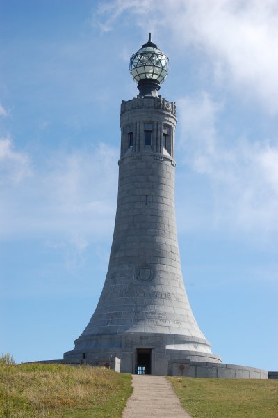
 The Massachusetts Veterans War Memorial Tower was built in 1932 as a tribute to courage, endurance, loyalty and self-sacrifice, shown, by the state’s men and women in uniform. To amuse those whose day trip involves the total effort of walking round the summit path before having a sandwich and coffee then heading home having seen the wonder of the mountain called Greylock, there are several engraved stones beside the path, dedicated to Henry David Thoreau; (July 12, 1817 – May 6, 1862) an American author, poet, and abolitionist.


The walk back down seemed harder than the climb up, the rocks which acted as well placed steps on the climb up now became mini cliffs ready to trap the unwary walker in twisting an ankle or two. Back at the Visitor Centre I removed my boots and as I got back in my car, looked up at the summit and took comfort in the fact that I had conquered on foot a mighty 8 miles of the AT… perhaps next time I can find another walk that will add a few more miles and reduce the remaining 2,173 miles I still need to do to complete the AT !


http://www.mass.gov/dcr/parks/mtGreylock/index.htm

Friday, September 9, 2011

The Devil wears a Tux

As I had a long journey this morning to get to my photo shoot. I climbed out of my nice warm bed at just before 5am. As always, first thing is to hit the coffee pot and get a breath of fresh air, with a fresh cup in hand I opened the back door and was about to step out on to the porch when I was greeted by the metal trash bins out in the back being knocked over. Creeping out to the porch, I instantly, realised who the intruder was, that smell is unmistakable, not as bad as I had been led to believe before moving over here, but bad enough. There was the culprit resplendently dressed in his black and white tuxedo, our friend the local skunk. Despite the smell, skunks are clean animals and groom themselves well, this male about 2 feet long without his tail, had vivid bright white stripes set against the jet black body fur. 

Skunks will eat whatever comes along so the trash is an ideal opportunity for them to scavenge.  Although they have excellent senses of smell and hearing they have poor vision, so it's possible to sit down with the camera and take photographs without fear of the critter running off having seen me. Today I didn't have time to grab my camera but I have several shots of him in the garden on his previous visits.


 Even the famous Charles Darwin made comment in his book the Voyage of the Beagle –

“We saw also a couple of Zorrillos, or skunks—odious animals, which are far from uncommon. In general appearance the Zorrillo resembles a polecat, but it is rather larger, and much thicker in proportion. Conscious of its power, it roams by day about the open plain, and fears neither dog nor man. If a dog is urged to the attack, its courage is instantly checked by a few drops of the fetid oil, which brings on violent sickness and running at the nose. Whatever is once polluted by it, is for ever useless. Azara says the smell can be perceived at a league distant; more than once, when entering the harbour of Monte Video, the wind being off shore, we have perceived the odour on board the Beagle. Certain it is, that every animal most willingly makes room for the Zorrillo.”

After about half an hour the skunk realised that attempting to get in to the metal bins was useless and having eaten all the wind fallen sycamore seeds lying around, flicked his tail and disappeared up the garden and under the fence…. Until the next time !